r/MapPorn • • 2h ago

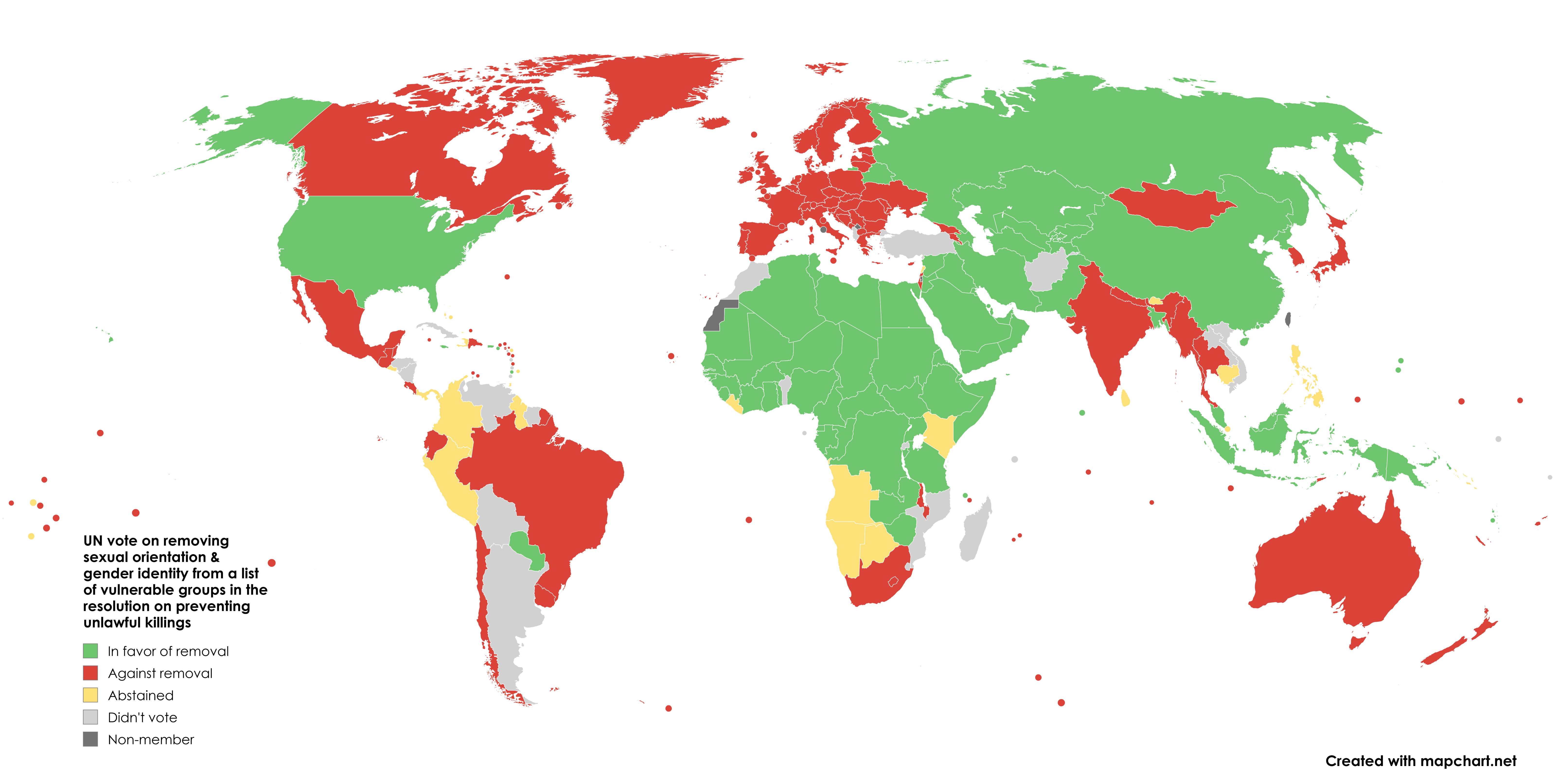
How countries voted on the UN amendment to remove sexual orientation & gender identity from a list of vulnerable groups mentioned in the resolution on preventing unlawful killings

Post image
1.2k Upvotes

r/MapPorn • • 1h ago

The United Nations Human Rights Committee voted yesterday in favor of a new resolution calling for intensified efforts to combat violence against women

Post image
• Upvotes

r/MapPorn • • 8h ago

A Lifeless World: What Earth would look like without life

Post image
435 Upvotes

A subsoil color map of the world.


r/MapPorn • • 18h ago

How long it takes to get anywhere in Western Australia from Perth

1.7k Upvotes

This simulates driving every road away from Perth until you've reached (essentially) every drivable documented road in Western Australia. This uses a custom formula that accounts for speed limits, population density, road curves, and intersections. The farthest point is more than 2x what it would take to drive all the way across Texas.


r/MapPorn • • 18h ago

Sex ratio of the world population (males per female)

Post image
1.7k Upvotes

r/MapPorn • • 1h ago

Americans who reported Spanish ancestry in 2021, excluding Latino Americans

Post image
• Upvotes

r/MapPorn • • 6h ago

Ranked: Which Regions Use the Most Oil Per Person?

Post image
137 Upvotes

Figures include industrial and transportation demand. Regional classifications follow Eni's methodology.

Source: Eni, World Energy Review 2026


r/MapPorn • • 2h ago

Proportion of people below the poverty line in France

Post image
69 Upvotes

r/MapPorn • • 3h ago

There are at least 15 reposts of the same shit in the last month

Post image
56 Upvotes

Seriously what is this crap


r/MapPorn • • 13h ago

The turnaround.

Thumbnail
gallery
278 Upvotes

Aurangzeb spent 27 years of his life just to crush Marathas which only resulted in ultimate destruction of Mughal empire.About 100k mughal soliders died each yea (many from fever, exhaustion and lack of food).

Niccolao Manucci contemporary European observer said-- "Aurangzeb regretted becoming entangled in the war because it had not succeeded as hoped."

How would have history played out if he had listened to his generals and just had left Marathas alone?


r/MapPorn • • 5h ago

Results of the 2004 Spanish general election by constituency.

Post image
64 Upvotes

r/MapPorn • • 18h ago

France's most common surname, department by department

Post image
645 Upvotes

r/MapPorn • • 2h ago

Parties to the EU Charter of Fundamental Rights and states with an opt-out (Poland)

Post image
36 Upvotes

r/MapPorn • • 13h ago

3D map of ski runs on Mt Hood, OR

Post image
212 Upvotes

Hi folks! I put together a 3D map of Mt Hood with Timberline and Mt Hood Meadows ski slopes featured. Using QGIS, I pulled osm data and then pulled the map into Blender. Post processing in Affinity. Let me know what you think and if anything could be improved!


r/MapPorn • • 3h ago

All of Singapore fits within the M25 in London

Post image
32 Upvotes

Taken using thetruesize.com


r/MapPorn • • 33m ago

This piece of Minnesota can only be reached by road through Canada, on a 10 km gravel road that ends at an unmanned border crossing (Northwest Angle, Minnesota, Sentinel-2, Oct 2025, border outlined in gold)

Post image
• Upvotes

r/MapPorn • • 21h ago

Yemen Offensive as of 17/11/2026 [Houthis in dark blue, Saudi-backed PLC in red]

Post image
841 Upvotes

r/MapPorn • • 1d ago

When the sun will set tonight in New England (11/17/2026)

Post image
1.7k Upvotes

r/MapPorn • • 2h ago

Growth of Seljuk Empire under their first three rulers

Post image
21 Upvotes

r/MapPorn • • 18h ago

Marin County, California [OC]

Post image
436 Upvotes

r/MapPorn • • 5h ago

Three Peninsulas, Two Centuries Apart on the Clock: EU Beach Resorts on Kassandra and Sithonia vs. Mount Athos's 1,000-Year Monastic Border and 500m Offshore Exclusion Zone [OC]

Post image
35 Upvotes

Data & Sources:

- Coastlines, isthmus geometry & elevation: OpenStreetMap high-resolution vector polygons & SRTM terrain relief (EPSG:3857 Web Mercator)

- Border & constitutional parameters: Article 105 of the Constitution of Greece; Joint Declaration No. 4 of Greece's 1979 European Communities Accession Act (and Schengen protocol); Greek Legislative Decree 2623/1953; Hellenic Coast Guard 500m maritime exclusion perimeter

- Built with d3-geo, Python, and custom SVG/Canvas cartography

Context: In northern Greece, the Chalkidiki peninsula splits into three narrow fingers jutting into the Aegean. While Kassandra and Sithonia operate as ordinary EU Schengen resort peninsulas, crossing past Ouranoupoli to the Frangokastro fence enters Agion Oros (Mount Athos), a 335 sq km self-governed part of the Greek State administered by 20 ruling Eastern Orthodox monasteries (where founding a 21st is forbidden by law).

Alongside the 1045 AD ban on women (and domestic female farm animals/hens, with monastery cats kept as the practical exception to guard grain and 15,000+ medieval manuscripts from rodents), adult men require an entry permit (a general daily quota of 100 Orthodox and 10 non-Orthodox visitors, plus direct monastery invitations), monasteries keep the Julian calendar (13 days behind Athens), and tower clocks still reset to 00:00 at sunset.

(I originally built these georeferenced layers for an 12-minute cartographic documentary on the peninsula's borders, history, and EU treaty carve-out. Full animated breakdown here if anyone wants to explore further: https://www.youtube.com/watch?v=1G_SbJGuS1I)

r/MapPorn • • 21m ago

Alabama compared with European countries on 6 measures

Post image
• Upvotes

r/MapPorn • • 18h ago

The last time a dem won statewide in each state

Post image
270 Upvotes

r/MapPorn • • 4h ago

Median age of people born in the country vs born abroad, EU, EFTA and Türkiye, 2025

Post image
14 Upvotes

r/MapPorn • • 11h ago

Was colour television broadcasting already in existence back in 1976?

Post image
45 Upvotes