r/openstreetmap • u/top-o-map • 9h ago
OSM Mappers are fast!

126
Upvotes
Destroyed Crimean Bridge on onlinetopomap.com
r/openstreetmap • u/Spanholz • Jun 22 '17
Hey OpenStreetMappers,
I wanted to share these websites/apps in some outdoor subreddits, which are probably useful for a lot of people. Is there something missing or something you want to add?
Maps
Apps (all work offline)
Routing Services
Printing OpenStreetMap Maps
Advanced/Other OSM based services
Last reworked the list in January 2022.
r/openstreetmap • u/top-o-map • 9h ago
Destroyed Crimean Bridge on onlinetopomap.com
r/openstreetmap • u/fadingvistas • 21h ago

I live somewhere in that box (obviously also not right in the middle of the box, somewhere random). I combine my daily tracks at the end of the month into one trace to upload to OSM. Before that I use JOSM's GPXedit plugin to delete points within bounding boxes (have to select manually and I have a .osm file to load as layer containing the boxes I want to censor, school and other stuff, I'll write a script sometime to directly delete all coordinates within those boxes in the .gpx). If some of those points where from a track that went through the box instead of ending or starting within, there will be a straight line at the track cut. I manually cut those tracks, and delete the lines, some months it's dozens, obviously can also be implemented in a script sometime.
This screenshot is old, my device is now more accurate and I walk more trails outside the city.
r/openstreetmap • u/Angel_Blue01 • 16h ago
I'm fairly new to OSM, but I'm learning to love it. My aims are fairly simple: adding missing features of interest to locals and visitors, such as local businesses and organizations, particularly in areas where I have surveyed on foot.
As a reference librarian, patrons frequently ask about various types of social/government/legal/business services, such as translation, notary public, send and receiving faxes, etc. It would be nice to have a ready-made map provided by OSM data!
I'm not sure how to tag that a given location offers a particular service that is not the primary purpose of the location and may or may not advertise. There is a service=* key, but the wiki states "The service tag should not be used to specify the services provided by businesses, including services to vehicles," without providing alternatives for business services. On the other hand, the tourism:hotel tag's wiki page offers examples of precisely the type of services what I'm looking to provide, seemly contradicting the service entry it links to. Which is "correct"?
Then there are services that OSM considers to be distinct, such as the office=notary tag. Although OSM appears to consider notaries to be distinct offices, in reality, notaries may be available at libraries, banks and other kinds of institutions.
I realize that I could add points with some these features within the existing areas, such as the notary within the bank, but this feels like a hack, and the relationship to the institution wouldn't be obvious to a person or a tool looking for those services.
What is the best practice?
r/openstreetmap • u/Routine-Citron-3094 • 1d ago
Hi. I'm pretty new to doing large scale edits on OSM (so far I've only sent minor corrections). I have a situation where I want to mark a gated community that's surrounded by wall. Is it a proper solution to mark it with both barrier=wall and area=true,landuse=residential at the same time?
r/openstreetmap • u/IamWimps • 1d ago
I made a travel app (Curio) that shows the monuments, museums and viewpoints around you, worldwide. OSM is one of its two sources, so here's how it uses the data, in case it's useful or someone spots a mistake.
Selection: historic in archaeological_site, monument, memorial, ruins, castle, fort, citywalls, city_gate, battlefield, wayside_shrine, wayside_cross, tomb, manor, milestone, boundary_stone; any heritage tag other than no; tourism museum, gallery, artwork, attraction, viewpoint; amenity theatre, library, place_of_worship. A name is required.
Filtered out: shops, restaurants, cafés, accommodation, tourist offices, bare historic=yes without other tags, and places whose only name is generic ("Viewpoint", "Church") and that have no wikidata or wikipedia tag.
I stopped querying public Overpass per map view and now build my own tiles from the planet file, so the app doesn't load the public instances
Are there tags I'm missing for notable places, or ones I should trust less?
r/openstreetmap • u/ljshamz • 1d ago
(Not sure if this is the right place, but if not, you all seem like the crowd who would know where to go!)
I’m always interested in knowing where municipalities start and stop, but it seems to be really hard to find an interactive map app that has both - most map apps don’t show low-level boundaries, and municipal boundary maps tend to be small, static images with no roads. Does anyone have a suggestion for how to get both? I’m open to doing a bit of configuring (e.g. downloading GIS layers) if there’s nothing out of the box. Thanks!
r/openstreetmap • u/MrDonas • 1d ago
I made Terento because getting OSM maps onto my Garmin from a Mac was more work than it should be.
It installs maps from existing OSM-based Garmin projects: OpenTopoMap, Freizeitkarte, MapRando, BBBike and OSMapaPL. It downloads each one from the project's own source, and the credits stay with them. You can also add your own .img if you build maps yourself with mkgmap.
Works as a Mac app or a web installer in Chromium browsers. It can update maps when the projects release new versions, and it only touches the maps it installed.
Around 400 installs so far on 45 Garmin models. Feedback from people who know the Garmin map side better than me is very welcome, especially which other OSM map projects would be worth adding.
GitHub: https://github.com/VooZ2/terento
Website: https://terento.app
r/openstreetmap • u/brown_dwarfy • 1d ago
I remember using certain site for osm projects when I was first learning osm like a year ago
it had like a dark UI
let you edit in online osm editor, josm and qgis
and for each task you completed you'd earn some points and could even check out rankings with other editors
does anyone know what site I'm talking about? I can't find it at all T^T
r/openstreetmap • u/kwhatever • 2d ago
r/openstreetmap • u/Yeethecola • 3d ago
I made some 3d models of buildings in vespucci a while back. There are more but i forgot some of them
r/openstreetmap • u/SciGuy0628 • 3d ago

Hey all,
I am reaching out to the OpenStreet community to help with a project I had worked on for about a year. I have compiled a database for all abandoned ski areas on the east coast and mapped out trails, lifts, etc. I had done all of this in Google Earth but with the end of Google Earth support I wanted to migrate all this data to OpenStreet.
I am wondering how I could transfer this data over to OpenStreet or even if such a thing is possible. Any help at all is appreciated. Thank you.
r/openstreetmap • u/lolasch • 3d ago
Hey people,
yesterday I finally published the first stable Version of https://opendogmap.org
Similar to other projects, like OpenRailwayMap, it focusses on showing the features from OSM that are relevant for a certain peer group. In this case for dog owners: benches, trash bins, poop bag dispensers, dog parks and much more.
Additionally, it shows whether dogs are allowed in a restaurant, shop etc. If this information is lacking, people can quickly edit it using their existing OSM-Account. Also, favorite places are saved there. OpenDogMap itself does not collect any data.
Next to the map feature, there is a routing feature with GraphHopper. It focusses on calm routing via walking. It has the nice touch, that you can start a round trip from any given point with a certain duration, if you want some ideas for a walk with your pet.
I wrote a blog article (in german) where I explained more reasons behind the project if someone is interested: https://blog.pfennig.tech/opendogmap.html
For the start, OpenDogMap only covers Europe, since hosting the custom map tiles and GraphHopper is a bit pricey. If some countries should be added, hmu, the whole globe is too much for the start.
The app is implemented as PWA, so you can save it to your home screen. It is open source, and, full disclosure, was developed with help of agentic coding. You can find the repo here: https://gitlab.com/pfennig42/opendogmap
I know, that there are other projects, like MapComplete, that already try to do similar things, but I always had some usability problems with them. Together with the routing, that I often missed when being in foreign cities, I decided to finally pursue this project.
Thank you for reading until here, and I am happy to hear about any feedback or ideas!
Pfennig
r/openstreetmap • u/Te6kiGomna • 3d ago

Hi r/openstreetmap!
I'm working on a project to search OSM data via Overpass, but with sentences instead of queries. You can check out the project at https://hippomaps.ch . It is growing into a full mapping service (spoken turn-by-turn navigation, public transport navigation, POI search, etc).
At its core though I think it might be useful as a tool instead of overpass-turbo. I've added the option to show the parsed Overpass query as well as the option to download the queried data.
It's super fast! I use LLMs for coding this, but there are no LLMs in the final product. The input sentences are tokenized and translated to queries. The benefit is that it's deterministic and fast.
Try it out and let me know what queries work and don't work for you. I'd be curious to see that.
overpass-search: https://gitlab.com/cdutsov/overpass-search (the language to overpass query translator)
hippomaps: https://github.com/cdutsov/hippomaps (the maps and website)
Stuff to try out: "hiking trails from X to Y", "huts between X m and Y m within 20 km of Z", "coffee shops along (river, lake)", "X in country/area Y", etc.
r/openstreetmap • u/momen535 • 3d ago
Hello. I'm new, and I'm wondering which Satellite Layer is the best for tracing?
I started with Bing Maps Aerial but I noticed that it's using an outdated Imagery for my city and the quality is low, then used Mapbox which is a bit newer but the image quality is a bit off.
r/openstreetmap • u/TomasArt_official • 3d ago
Hi everyone,
I’m a solo developer from the Czech Republic, and I’ve been building dohledejto.cz/mapa, a self-hosted maps and turn-by-turn navigation platform powered by OpenStreetMap data (© OpenStreetMap contributors).
It’s built for the Czech market (in Czech) and is part of my independent, privacy-first search engine dohledejto.cz. Here’s how mapping, offline storage and crowdsourced traffic work under the hood:
My philosophy is simple: don’t collect or store user data unless it is strictly necessary for a feature to work.
You can try it at dohledejto.cz/mapa (and the search engine at dohledejto.cz). I’d love feedback on the architecture, routing, or the traffic aggregation. :)
r/openstreetmap • u/V-Blocked • 4d ago

The picture shows buildings that I have ever edited but ~90% of what is shown are buildings I created
r/openstreetmap • u/ppitm • 2d ago
This is basic functionality in Google Maps and every GIS every built. Why can't we right-click the map and then click to add nodes to a polyline?
r/openstreetmap • u/Far_Departure_1580 • 3d ago
Spent some time improving coverage in Nova Friburgo, Rio de Janeiro, Brasil. I added stairways, footways, stairways, seats and a roundabout.
I used both Mapillary and StreetComplete on my iPhone. I created my Mapilary account as TheCelestial to help me mapping Nova Friburgo, although it is owned by Meta.
My goal is to gradually finish mapping the urban area of Nova Friburgo, adding more places for OpenStreetMap, since the coverage is partial.
Anyway, link:
r/openstreetmap • u/agilek • 4d ago
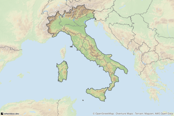
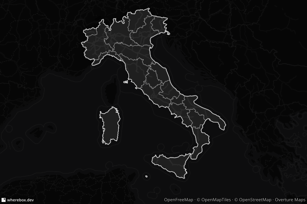
Hello dear OSMers, I would like to present to you a new project of mine: a static maps API based on data from OSM and a few more providers. If you are building an app and "where" matters, you can call my service with a simple URL like this https://api.wherebox.dev/v1/map.png?area=italy to get a map of Italy.
But this is just the beginning - there is way more parameters you can squeeze into URL so you can show e.g. neighbouring countries, points for your locations, routes or render the map in a different style (see Italy map with a dark preset). All options are captured in documentation.
The service is free to use (with generous fair use of 10K renders/month).
If you are developer, I would appreciate any feedback to it!

r/openstreetmap • u/Inner_Jello_2105 • 4d ago
Hi folks,
I live in a sub-development where a large chunk hasn't been entered into OSM. What little has been added is missing detail or misleading.
Most of the buildings are placed around Avella Circle, but there are a few other tiny named streets involved. So several of the buildings have addresses of their individual units on different streets, based on which street each unit's garage faces. Many of the main entrances face a different street than the garage, or don't face a street at all. E.g. my garage and thus address is 2962 Franklin Drive, but my front door faces Avella Circle, and is *right next to* 2831 Avella Circle's front door. Easy to navigate right?
What's the recommended way to get this entered? I was adding plain Address features on the building boundaries, located at the garages. So at least the street names line up. Should those be denoted as private Parking Garages, and also add a separate Entrance point? Or does that seem too busy for small-ish residential units?
Thanks for the insight!
r/openstreetmap • u/Pure-Bake828 • 5d ago

If so, how would you go about tagging this little bit of way?